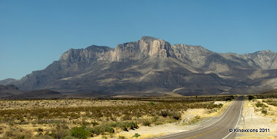
This was still about 15 miles south. The mountain rises dramatically from the desert floor. The peak in the center is El Capitan, which has an elevation of 8,085 feet. Guadalupe Peak, the highest peak in Texas at 8,749 feet, is directly behind El Capitan. (As always, double-click on an image to view a larger version! It's worth the "extra" clicks!!)

US Highways 62 and 180 intersect with route 54 just south of the mountain. I traveled a short distance west on 62/180 to take the above photo.

Turning back to the east, highway 62/180 heads into the mountains. (This was taken as I was driving down the highway – not a recommended practice by the way - hence a bit of glare in the center of the picture.)

El Capitan as seen from Guadalupe Pass, which is at 5,420 feet.

The view from my site at Pine Springs Campground in Guadalupe Mountains National Park. Not quite as imposing as El Capitan but impressive nevertheless.
I had been told by one of the campers at Monahans Sandhills that even if I did no hiking, it was worth the drive to Guadalupe just to see the Mountains. I totally agree with that assessment.
I had also been informed that it was extremely windy at Guadalupe. In fact, that is the primary reason I didn't go there last year. And, yes, it was quite windy. The van was buffeted all night long as the wind howled through the mountains. They have some nice trails too (some even designated as easy), but I didn't do any hiking – too windy and the left leg is still bothering me.
No comments:
Post a Comment